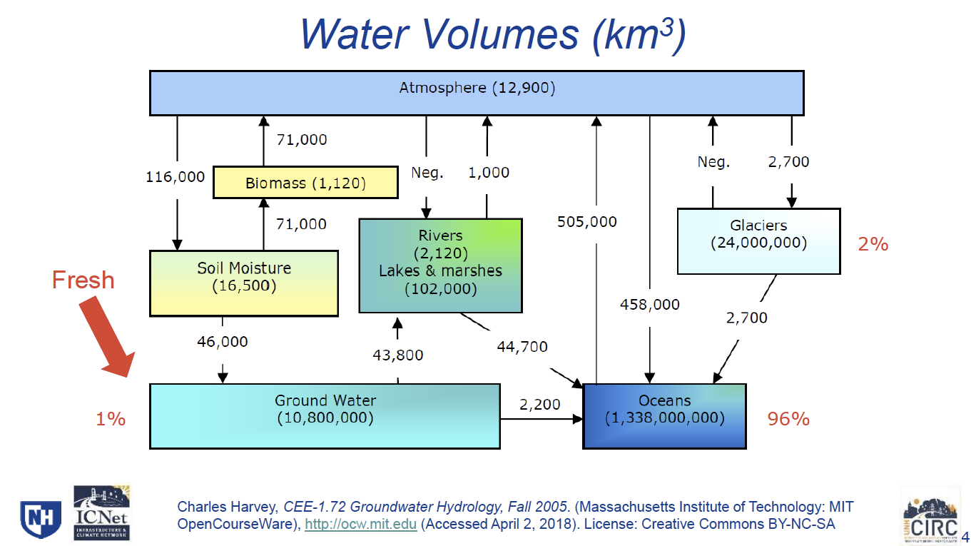
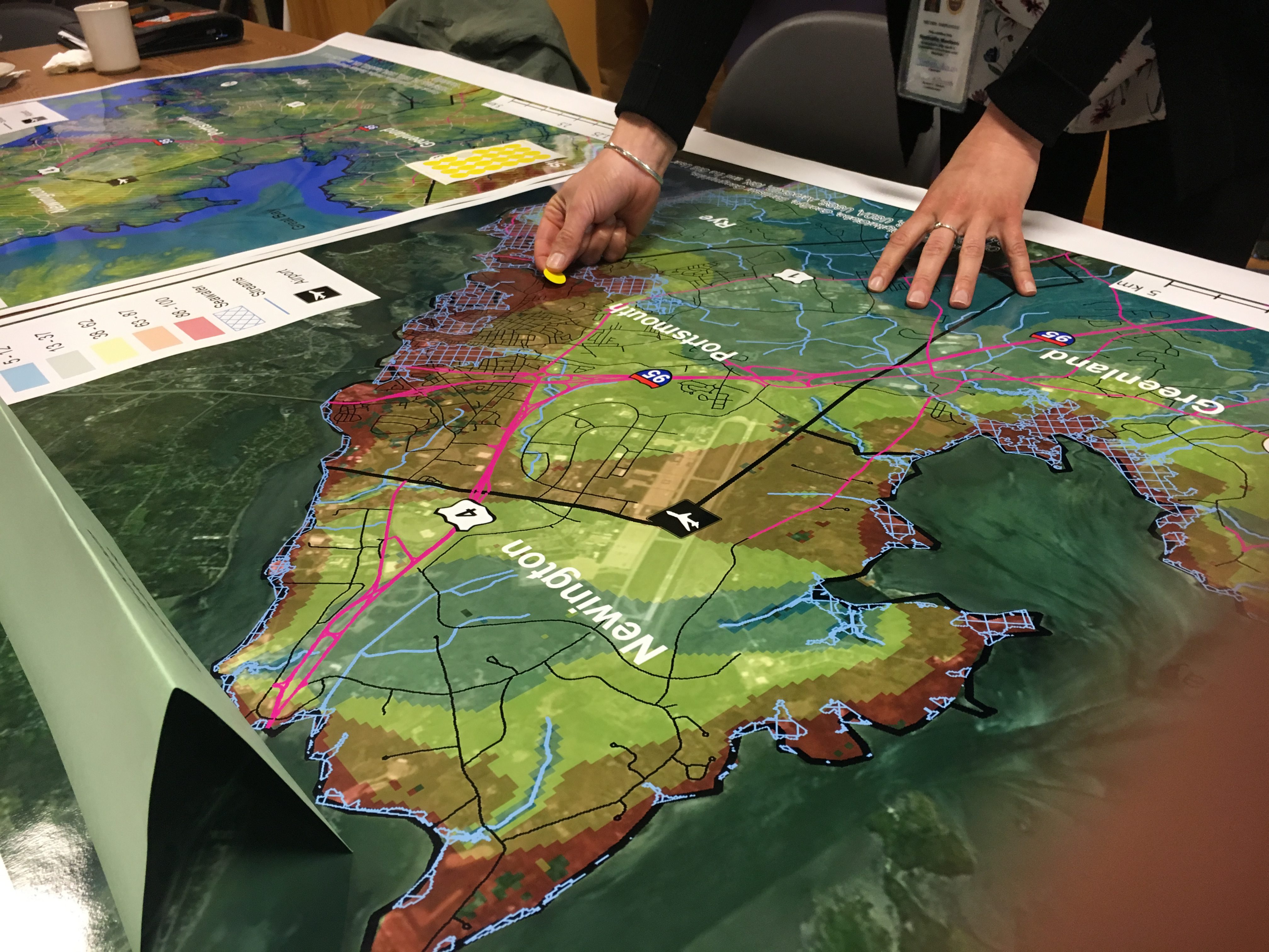
On April 26, the NH Coastal Adaptation Workgroup hosted the workshop “As Sea Level Rises Groundwater Does Too – What is at Risk When Groundwater Rises?” highlighting infrastructure and areas vulnerable to groundwater rise across the coast of New Hampshire. Speakers included Jayne Knott and Jennifer Jacobs (University of New Hampshire and the Infrastructure and Climate Network (ICNET)), Kyle Pimental (Strafford Regional Planning Commission), and Dale Pike (Newmarket Town Council). In May 2017, Jayne’s research found that some roads – even those miles inland from the coast – are threatened by rising groundwater, but as we learned at the workshop roads are not the only infrastructure that will be impacted. Participants in the workshop learned where groundwater is expected to rise and by how much, and had an opportunity to identify areas that already flood (like the basement of the Shapley Drisco House at Strawbery Banke on December 5, 2017) on large maps of communities within the study area. The information gathered will be used to prioritize communities and targeted areas for additional analysis. For a complete set of slides from the presentations visit HERE. Major takeaways included: Groundwater Holds Most of Earth’s Accessible Freshwater Of all the water on the Earth, 97% is saline and found in oceans, seas, estuaries, and saline groundwater. Of the freshwater (the remaining 3%) most is inaccessible and stored in glaciers, snowfields, and the soil. Fresh groundwater makes up roughly 1% of the Earth’s water, and yet we rely heavily on groundwater as a source of drinking water for communities and individual homes. This alone is reason enough to protect groundwater sources.
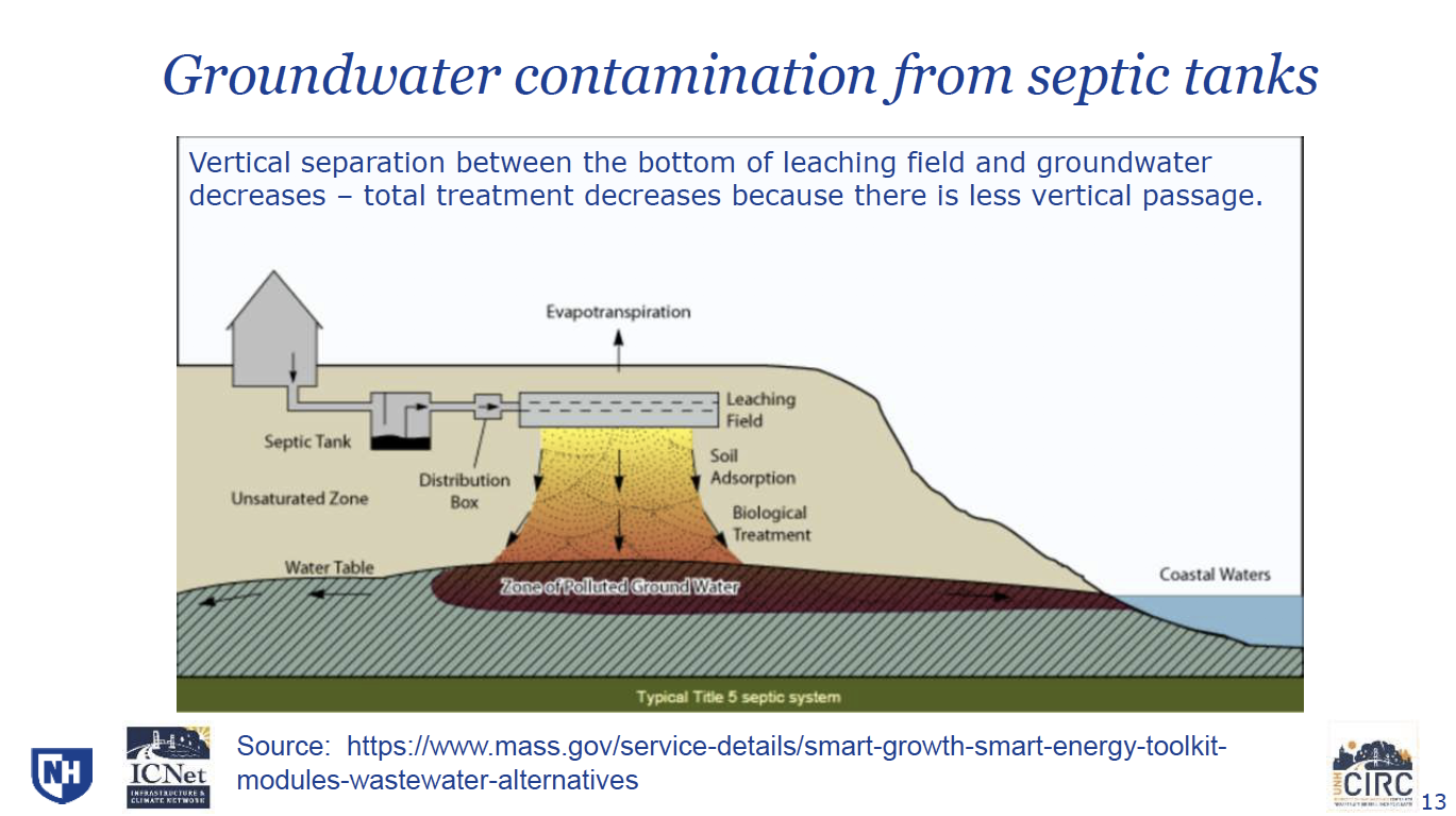
As Sea Levels Rises Groundwater Does Too The Science and Technical Advisory Panel from the NH Coastal Risks and Hazards Commission, reports that sea levels in New Hampshire are rising and “are expected to rise between 0.6 and 2.0 feet by 2050 and between 1.6 and 6.6 feet by 2100” (Preparing New Hampshire for Projected Storm Surge, Sea-Level Rise, and Extreme Precipitation, 2017). As sea-levels continue to rise, groundwater will rise simultaneously. Groundwater flooding (inundation) is even expected in areas where no surface flooding is anticipated, and as far as a 2.5 miles (4km) inland. Not Everywhere is at Risk A key message that I took away from Jayne’s presentation was that not everywhere will be impacted by groundwater rise. She was clear to point out that groundwater rising creates vulnerabilities, but that it is only a concern where rising levels encounter a low road, contamination site, freshwater wetland or salt marsh, or infrastructure – like a basement. Where the groundwater level is naturally low, there is not an immediate concern. The model identifies areas where groundwater will rise, not where it will intersect the ground surface. Vulnerable areas are where groundwater is already close to the surface. Potential for Groundwater Contamination Rising groundwater raises concerns about contamination from septic systems. These systems are installed with vertical separation between the leaching field and groundwater to allow for soil adsorption and biological treatment. If groundwater rises and decreases the vertical separation, we can anticipate potential contamination. Similarly, groundwater may mobilize contamination from disposal sites if rising groundwater encounters contaminated soils.
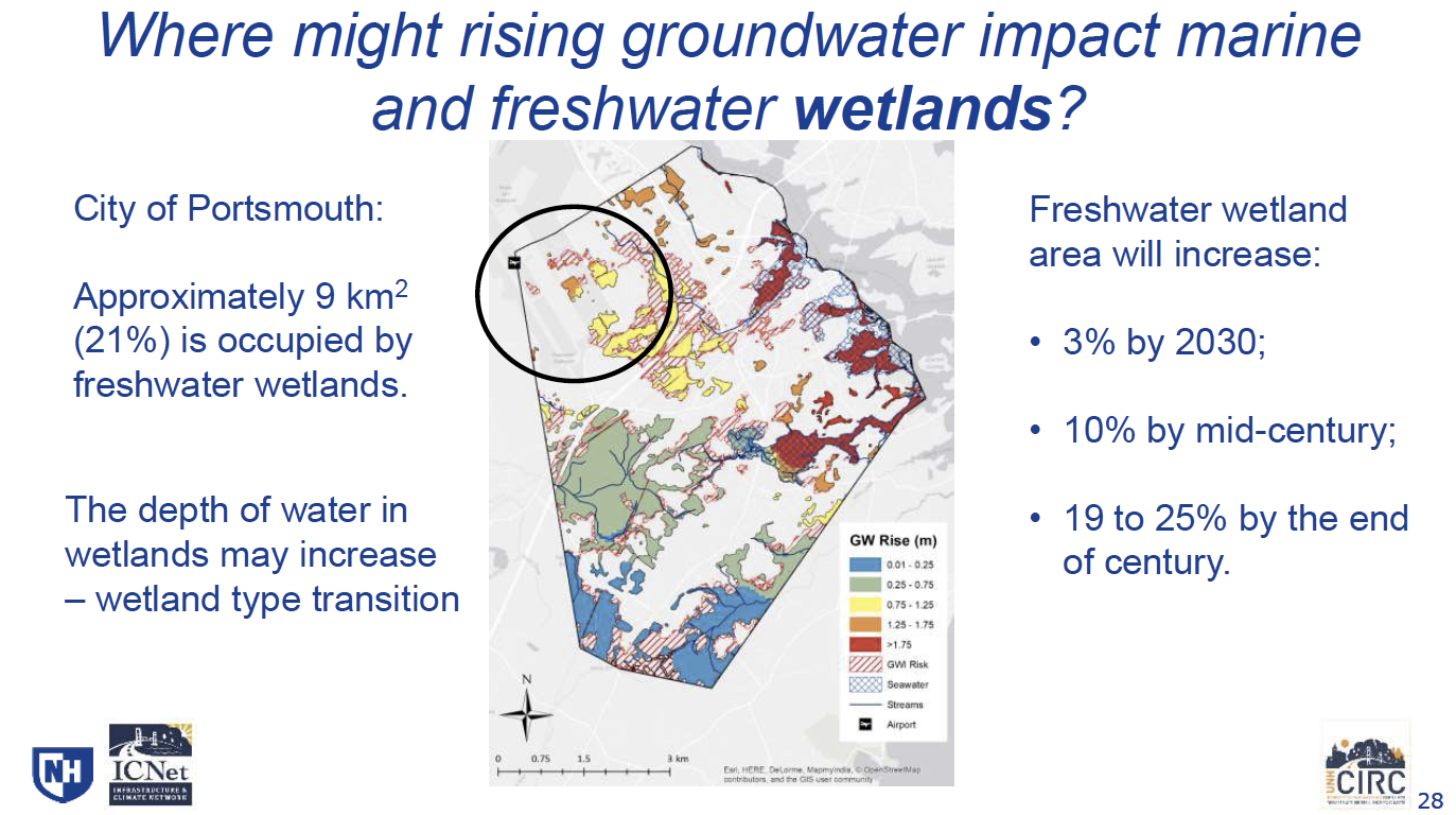
We May See Freshwater Wetlands Grow and Change As groundwater rises and breaks the surface in some areas, we may see new freshwater wetlands develop overtime. Based on the model, freshwater wetland area is expected to increase 3% by 2030 (10% by 2050 and 19-25% by the end of 2099) in Portsmouth, NH. In already established freshwater wetlands, the depth of water is also expected to increase which could change the structure and function of existing wetlands. To preserve ecosystem services we receive from wetlands, we need to continue protecting them.
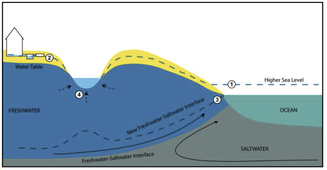
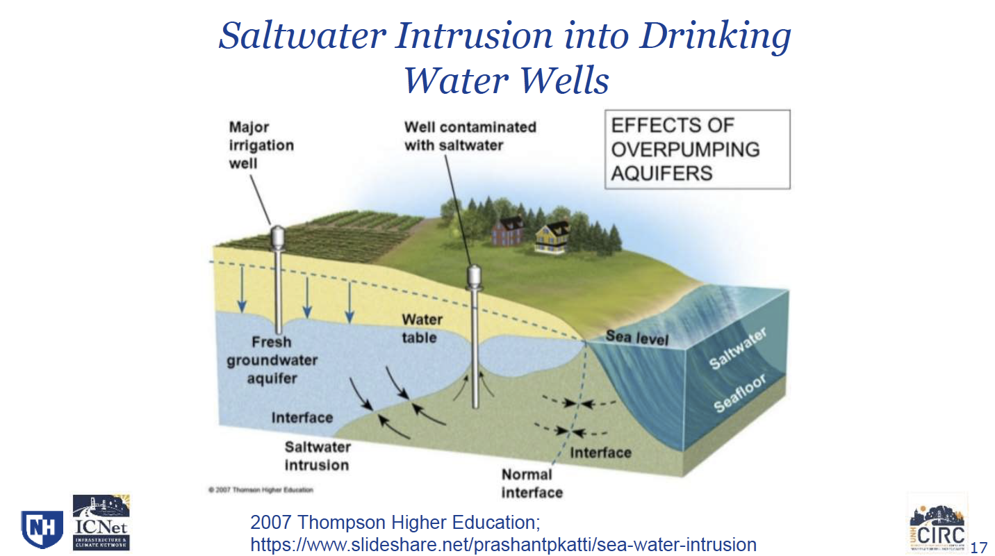
Saltwater Intrusion into Drinking Water Wells Rising sea-levels changes the normal interface between salt water and fresh water – moving further inland (as seen in the slide below). Following Jayne’s presentation Kyle Pimental from the Strafford Regional Planning Commission and Dale Pike from the Newmarket Town Council spoke about how the community is using the groundwater model to identify vulnerable water sources in Newmarket. More information on the project in Newmarket is available HERE. Slides HERE.
What We Can Do Fortunately, there are opportunities to implement adaptation strategies to offset the effects of rising sea-levels and groundwater. The end of Jayne’s presentation included options for what to do next and included recommendations for:
For a complete set of Jayne Knott or Kyle Pimental’s presentations visit the Community Workshop Series page by the NH Coastal Adaptation Workgroup. (Photos from Jayne’s presentation.) |