
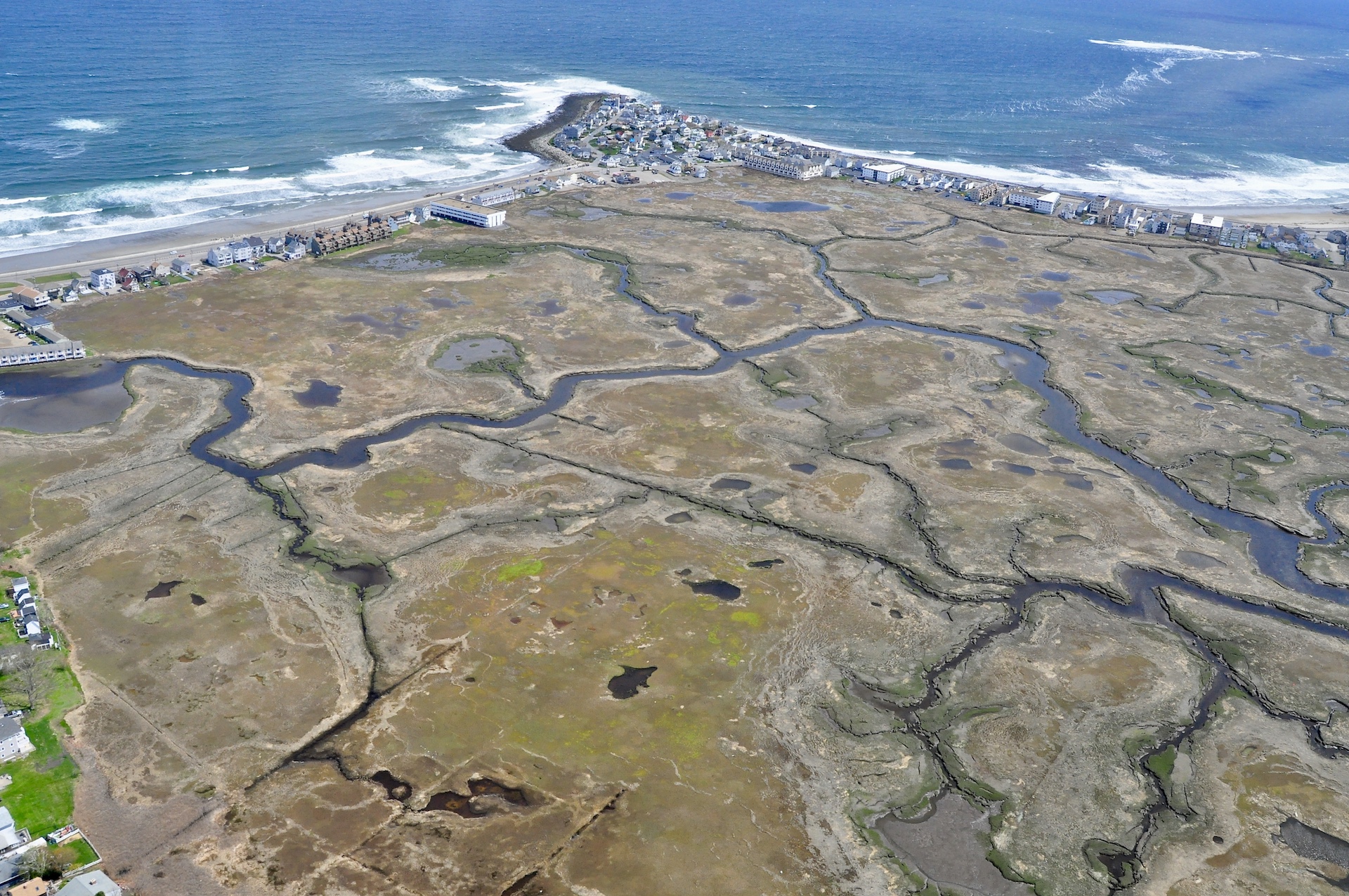
Hampton-Seabrook Estuary Collaborative
The Hampton-Seabrook Estuary Collaborative (HSEC) is a group of local, state, and federal organizations and agencies focused on improving the health and vitality of the Hampton-Seabrook Estuary and its communities. Led by a steering committee composed of representatives from US Fish & Wildlife, New Hampshire Coastal Program, PREP, and the Seabrook-Hamptons Estuary Alliance, HSEC put out a survey in 2020 to better understand the existing science and needs of the Estuary, leading to the development of three working webinars and a Prospectus to help guide the efforts of the collaborative. In addition, results from the survey and webinar series helped to develop “The Commons” – a tool that any interested organization can use to identify projects, resources, and potential partners to support science and monitoring collaborations in the Hampton-Seabrook Estuary.
Next HSEC Meeting
Meeting Details
Date:
Time:
Location/Link:
Focus:
Meeting Materials
Agenda:
Additional Materials:
Contact Trevor.Mattera@unh.edu for questions or more details
Click the link above to be taken to the Grant List & Project Tracker of the HSE Collaborative. These resources are updated intermittently by the HSE Collaborative Coordinator.
Please contact the coordinator at HSE.Collaborative.Coordinator@gmail.com to add a funding opportunity or project to this list or for any questions. Please refer to grants.gov (for federal grant opportunities) or the funder website for the most up to date information.
Past HSEC Meeting materials
Miss a HSEC meeting? See below for the agendas, minutes, slides, and/or other materials presented.
HSEC Survey and Webinar Series
A survey of coastal science and management organizations was conducted to better understand existing and needed science and data, and three webinars were held to discuss topics of shared interests and to identify ideas for how to enhance collaboration in the near future.
Hampton-Seabrook Estuary Commons
| sub-theme | Partners | Resources | Suggested Next Steps and Gaps |
|---|---|---|---|
| Adaptation, Ditch, Dredging, Fish, Flooding, Flora, Habitat, Impacts, Invasive Species, Management, Mapping, Models, Organisms, Regional, Regional Restoration, Salt Marsh, Salt Marsh Sparrow, Sediment, Shellfish, Shorebirds, Stations, Vegetation, Water Levels, Water Quality | |||
| Salt Marsh Sparrow | PREP, UNH, NHFG, GBNERR, ASNH. | Saltmarsh sparrow patch prioritization tool: acjv.org. Saltmarsh Sparrow distribution study in HSE (2007). Shorebird use (2006-07, 2018-20). High resolution tidal mapping on CoastalViewer NH marsh plan. Saltmarsh sparrow monitoring project (2021) | Understand site conditions that maximize reproductive success for salt marsh sparrows Bird surveys saltmarsh & Nelson's sparrows Identify sparrow location/breeding areas at a selection of marshes (complement summer surveys with additional capacity/rapid surveys) More field data of Salt Marsh Sparrow and Nelson’s Sparrow (w/ SHARP protocols) What techniques should be used to help protect salt marsh sparrows from nest flooding and loss? |
| Shorebirds | CP, SHEA, GBNERR, UNH, NOAA | Survey of Migratory Shorebird use (2006-07, 2018-20). High resolution tidal mapping on CoastalViewer NH marsh plan. Collect dune profiles within plover nesting areas Recently completed field work on shorebird stopover (Falls of 2018-20 plus spring of 2019). Report in preparation. SHEA holds at least 4 general outreach projects on topics ranging from birds of the estuary and the history of salt marsh haying. | Conduct survey of common terns & roosting information for shorebirds What specific marsh features correlate with bird population & productivity? Prioritize marshes for intervention and identify fringe marsh as refuge (e.g. Great Bay or upriver) Specific marsh monitoring beyond SHARP points (HSE, Rye) Where some shorebirds roost within the large HSE ecosystem. Data on marsh-nesting Common Terns (state threatened) are over a decade old. Bird surveys that contain information on Saltmarsh Sparrows and Nelson's Sparrow would be of great interest, especially if monitoring followed SHARP protocols (see tidalmarshbirds.org) and in terms of best habitat management. |
| Shellfish | Normandeau Associates, ??? | Annual soft shell clam survey since 1969; Collect soft shell clams for neoplasia analyses Water quality samples to investigate potential and real pathogens in water and shellfish; potentially collecting data from sondes in the HSE NHDES has provided funding and the Shellfish Program (Chris Nash) has done other work | Population dynamics & toxicity in oysters and soft shell clams. info about other key habitats like shellfish beds that may have relationship with the marsh habitat; Data on toxic contaminants near the clam flats and how they might be impacting the clams. |
| Fish | UNH | Fisheries ; Monthly juvenile fish surveys using bag seines; monthly seine sampling for fish since 1975. Data on American eel in the HSE (data collection completed 2012); My current project with Seabrook Middle School is evaluating eel use of the Cains Brook Mill Creek subwatershed (2020-2022) | more data on marsh use by higher trophic levels such as fish |
| Impacts | NFWF | Species presence absence, model land use, current condition assessments NFWF Habitat Protection Project | Impacts of salt marsh disappearance due to sea level rise on species that use salt marshes. Additional focused studies at a very detailed level (i.e., quadrat or transect scale) would be helpful, both related to plant communities and soil elevation but also to salt marsh sparrows. |
| Flora | Data on rare plants and exemplary natural communities. Collect macrobenthic community data within the HSE Federal Navigation Project periodically | Benthic community Many previously documented rare plant species and exemplary communities with outdated records. |
|
| Adaptation, Ditch, Dredging, Fish, Flooding, Flora, Habitat, Impacts, Invasive Species, Management, Mapping, Models, Organisms, Regional, Regional Restoration, Salt Marsh, Salt Marsh Sparrow, Sediment, Shellfish, Shorebirds, Stations, Vegetation, Water Levels, Water Quality | |||
| Sediment | UNH, NERACOOS | 2020 Overwash study to understand overwash and the contribution of overwash to suppyling the marsh with inorganic sediments. | Since 2015 UNH team piloting projects to correct legacy effects of agriculture and mosquito control in Great Marsh with a goal to apply techniques to HSE in the future. Detailed elevation data (soon to be released LiDAR hopefully will solve), understanding of impacts of catastrophic storm events - hard to research / model because stochastic. USFWS to share examples (Many marsh surfaces need to be stabilized first (through Tier I steps) before they are able to cope with sediment addition) Increase number of stations to assess elevation (i.e. is the marsh keeping pace with SLR?) Quantify amount and variability of flux of nitrogen, carbon, sediments from watersheds to estuaries (storm event, seasonal, interannual), and how conditions in the estuary responds. Where are the farming embankments in the HSE and what are the most appropriate methods to remove their negative impacts? Sediment budget Evaluate concepts for sediment placement (eg. tld, mud motor, sediment injection) Sediment dynamics; How do coarse grained sediments from inlets become incorporated in salt marsh sediments? Will salt marshes accrete more rapidly where densely ditched areas are restored through ditch remediation? |
| Restoration | USFWS, NHFG | Planning salt marsh restoration Completed dune restorations and continue profiling (2016-2020) lots of trend data and restoration techniques piloted at PKR to address marsh symptoms. SMARTeams assistance for salt marsh restoration projects. Assistance could begin immediately with increasing amounts as SMARTeams becomes more fully staffed. | 1) the extent of marshland that needs to be conserved/ restored for significant impact on the marsh and trust species, and 2) ownership of parcels in area. 1) data to evaluate best way to keep marshes healthy as SLR occurs (trend data about the marsh to info about specific restoration techniques) 2) info about other key habitats like shellfish beds that may have relationship with the marsh habitat Through SMARTeams we should be able to provide training for the collection of information and aerial imagery analysis to facilitate the development of conceptual salt marsh restoration designs. Restoration tools within the marsh and its migration pathways to enhance resiliency. a holistic focus that includes fixing hydrology (ditch remediation and runnels), sediment supply (thin layer addition, mud motor), promoting sparrow habitat and promoting migration. First steps will need to begin with pilot studies. |
| Dredging | UNH, NERACOOS | Hampton Harbor maintenance dredging was completed in 2019. Approx. 175,000 cy was dredged and placed on adjacent beaches in Salisbury and Hampton | if/how dredge material could be used in restoration efforts List of “elevation challenged” salt marsh units for possible sediment placement from harbor dredging Coordinate with USACE and NH Dredge Management Task Force to understand administrative considerations of beneficial use of dredged sediments. |
| Ditch | UNH | Ditch Characterization in the field (depth, width, successional status) Ditch layer published in the HSE Restoration Compendiul (2008) - 377 miles of ditches in HSE Elevation LiDAY from 4/2021 - USGS Quality Level 1 1.) Higher resolution topographical and bathymetric maps may also help improve model skill. 2) utilities mapping in 3 dimensions; 3.) re-evaluate SET on a consistent basis | How ditching affect plant communities, marsh resiliency and adjacent upland flooding |
| Mapping | OCM, NH DES, GBNERR, PREP, CP, NOAA | Salt marsh habitat maps through NH and the HSE. The source imagery was from 2013. The data are available here: https://coast.noaa.gov/digitalcoast/data/ccapsalthabitat.html Salt marsh resilience assessment High resolution tidal mapping with colleagues at NOAA (available on CoastalViewer). NH marsh plan. SLAMM/high resolution salt marsh mapping NOAA/Digital Coast provides access to imagery, topobathy lidar data, land cover, salt marsh habitat, and socioeconomic data, tools, and related training for HSE and the surrounding areas. Mapped shoreline protection structures and evaluated living shoreline site suitability TNC Water Resources Supplement maps (this includes salt marsh migration, water quality protection, flood storage). | High resolution bathymetry, and utilities mapping in 3 dimensions; more observations Detailed elevation data (soon to be released LiDAR hopefully will solve), understanding of impacts of catastrophic storm events - hard to research / model because stochastic. Data such as the "unvegetated to vegetated ratio" or proportion of the marsh above MHW are likely not available currently, and could be helpful to guide conservation implementation. Sediment levels, accretion rates, and tidal datum would also be valuable, and I'm not sure which (if any) of those are available and at what scale or level of precision. different sources of data and research compiled into a database/library to help build our overall understanding of the HSE health and identify management priorities. Atlantic Coast Joint Venture partners are using the “Resilient Migration Space” map layer produced by The Nature Conservancy to encourage and guide land protection that is needed in the migration zone. Many of our partners have been successful using USFWS wetland grant programs (NAWCA & NCWCGP) to fund protection and restoration work in these landscapes. |
| Habitat | NH marsh plan. Wildlife Action Plan maps For annual PREP reports and State of Our Estuaries Report, comes out every 5 years, PREP coordinates to collect data on salt marshes and water quality that gets analyzed and reported Train/coordinate volunteers who collect photos from stations at 2 marshes (Depot Road, Hampton Falls, Causeway St, Seabrook). Collected data (vegetation, water quality, nekton) in salt marshes. | Identify and assess condition of a selection of Hampton Seabrook marshes (i.e. diversity, proportion of high low marsh, etc.)? RAPID demo to better identify productive marshes 1.) Understanding of present day use of the estuary by both resident and transient nekton 2.) impact of burrowing crabs dune management and species reliant on dune. |
|
| Invasive Species | Coastal Program, NHDES | saltmarsh monitoring with picture posts - ongoing coastal flooding lending library - 2020-2022 Eradication of Perennial Pepperweed on the Northern New England Coast - start in 2021 | Procure permits and permissions to use herbicide on 2 pepperweed sites in HSE. extent and control of invasive species |
| Water Levels | GBNERR, SHEA, UNH, CP, NERACOOS | 2013 UNH JEL: 6 SET tables and marker horizons to understand salt marsh response to SLR. NH Salt Marsh Plan, entering Phase II NH Living Shoreline Site Suitability Assessment, completed in 2018 Remapping sea-level rise maps when new LiDAR data is released (spring 2021) NH Tidal Shoreline Protection Structures Inventory (completed 2016); Collect condition surveys of harbor and federal jetties, part of the Federal Navigation Project Hampton National Fish and Wildlife Foundation grant ( through 2021) to complete 50-60% designs for 2-3 habitat-friendly adaptation projects, (highlighted alternatives that include dredging all of Meadow Pond to building a seawall along the entire back marsh of Hampton, to road and home elevations, drainage improvements, and salt marsh ditch restoration.) identifying parcels for purchase/conservation. NH King Tide Photo Contest | Planning to establish in 2021 one or more Sentinel Sites in HSE with GBNERR. Funding is needed. Role of Dune overwash . . . (UNH Sea Grant), delayed in 2020 Leveraging Natural Resources for Resilience 2019-2021 (NH DES) Evaluate 6 existing SETS on bi-annual year cycle ; additional (e.g., low marsh, sparrow hot-spots, landward of rail and road barriers) More data on how marshes are responding to sea level rise; more data on approaches to assist marshes in responding to sea level rise (i.e., approaches that help build low marsh e.g. mud motor) Observations: Support Hampton Harbor Gage; telemetry based sensors to understand variability throughout estuary; normalize process for observations of flood elevations; Conduct regular gaging of some of the major tributaries hydrodynamic modeling for variability across marsh plain Locally derived tidal datum (MLW, MLLW, MHW, MHHW, HAT etc.), including any significant deviation from background datums, as well as good connections to NAVD88. This would allow a better understanding of marsh and channel inundation duration and more accurate calibrations for extreme water level analyses. |
| Models | NERACOOS, UNH | IOOS Coastal and Ocean Modeling Testbed grant titled "Improvement and Technology Transition of the Northeast Coastal Ocean Forecast System (NECOFS) for NOAA and IOOS Forecast Operations." (2018-2021) Goal is to improve the understanding and prediction of the combined effects of land processes and ocean circulation on coastal inundation in the coastal zone. Coupling hydrologic models (UNH Water balance model and the National Water Model) with a hydrodynamic model. Regional Biogeochemical model that will include HSE | Understanding how marshes impact the resiliency of the bay, through mitigating ocean acidification and eutrophication. New proposal to the IOOS COMT program with a focus on improving the model coupling techniques and are proposing to use the HSE as one of the pilot study areas. |
| Management | TNC, Coastal Program | Development of climate adaptation master plan chapters for North Hampton and Little Boar’s Head. Land Conservation Priorities for the Protection of Coasta Water Resources Social/resident data on preferences related to marsh management. | Synthesis of existing data to assess ecosystem health Helping the communities and residents to better understand the importance of the eco-services is an ongoing gap/need. Residents living along or adjacent to the salt marsh view the system as the threat as opposed to our biggest line of defense against flooding. |
| Vegetation | High Resolution Tidal Wetlands Maps (2020) with 14 tidal wetlands classes Salt Marsh Plan Tried to figure out ways to work with NHCP, SHEA and others to replicate marsh monitoring protocols so it is done same way across state. Helped out with invasive species monitoring as well (SOURCE) | Analyze High Resolution Tidal Wetland Maps and metrics from NH Salt Marsh Plan for basic statistics and general observations Update rare plant and exemplary community surveys Long term vegetation monitoring at multiple scales: Transects/quadrats at transitional zones, 3 seasons & remote sensing Capture hi resolution color aerial photos in 2023, map tidal wetlands, and conduct change analysis. |
|
| Adaptation, Ditch, Dredging, Fish, Flooding, Flora, Habitat, Impacts, Invasive Species, Management, Mapping, Models, Organisms, Regional, Regional Restoration, Salt Marsh, Salt Marsh Sparrow, Sediment, Shellfish, Shorebirds, Stations, Vegetation, Water Levels, Water Quality | |||
| Models | UNH, FEMA, USACE, Town of Hampton, Town of Seabrook , SHEA, NOAA | Water level data hydraulic modeling; includes sea-level rise predictions, storms, and changing tides Sea level affecting marshes model (SLAMM) (Published 2015, re-run planned 2021) Hampton Flood Mitigation Study, models water levels in the HSE Living Shoreline Site Suitability Model Site Assessment and Preliminary Designs to Mitigate Flooding in Hampton, NH Neighborhoods by Restoring Hampton-Seabrook Estuary Salt Marsh, 2019 ongoing shoaling in Seabrook (USACE); bathtub SLR mode (UNH GRANIT); Rockingham County flood maps (FEMA) Town of Hampton (2020): Milone and Macbroom used Woods Hole Group and UNH sensor data to determine hydraulics to map coastal flooding in Meadow Pond and west of Ashworth Ave. UNH CoCa Project (2014-2018): used 2 hydrodynamic models of flooding to perform integrated assessment of the economic and social values of wetland ecosystem services as part of adaptation strategies to coastal climate change, specifically sea level rise and associated increases in erosion and coastal flooding: -Advanced Environmental modeling Service (AEMS) -FVCOM to model tidal flooding and storm surge under present future SLR. | Local water level data and data quality metrics, elevation and land cover quality metrics, and ecosystem service assessments should be developed and tested. We need more water level information. System is now set up to collect that. Should keep it running for some time. 2021 SLAMM re-run Starting to work on mapping extreme water levels for different return periods. Also want to verify VDatum transformations at the local level. |
| Stations | NERACOOS | Hampton Harbor tide gauge water level sensor Northeast Coastal Ocean Forecast system (NECOFS), which include a high resolution inundation model for HSE. Topographic/bathymetric survey data & 2 months tidal data at 4 locations in Seabrook; Water level sensor in Hampton Harbor; 4 locations in Seabrook | Regular gaging of water levels and freshwater in-flows. A dedicated tide gage in the Harbor would be useful. Same goes for stream gages for some of the major tributaries. Additional gauges further in the estuary. long-term data; continuation or NERACOOS gauge (The NERACOOS gauge is underfunded and not formally recognized as a gauge by NOAA and lacks a formal datum. A more coordinated gauge network would be helpful--much of the work being done is ad hoc and the different entities don't engage with each other (Gopal/Hampton flood study), Hampton tide gauge, King Tide monitoring, SET monitoring, etc. Sea level rise implications on the HSE are the biggest risk to this system's long-term sustainability--sea level rise and the associated management actions taken by residents and land managers in the area have the potential to devastate HSE natural systems.) More observations of water level and flooded areas would help improve water level models. Detailed water level data on either side of potential restrictions. Also, the relatively new Hampton tidal station does not appear to have similar stats, data utility options, or ease of access/download as NOAA gauges |
| Management | Culvert design: South Main St culvert replacement Seabrook. Started 2020. In design phase; baseline tidal data to inform the design; For a brief period, the Horsley Witten Group monitored water elevations to inform culvert design Dredging of HSE Federal Navigation Project - 2019 - complete Construction of middle ground erosion control wall - 2005 - complete Town of Seabrook (2020): Horsley Witten deployed pressure transducers and determined hydraulics for tidal culvert replacement | Lack of understanding about how dredging and sediment management changes water levels. | |
| Adaptation | CP, SHEA, GBNERR | 2018 - Consensus Building Institute Grant, The Situation Assessment based on the results of an extensive survey completed by 69 Hampton residents and property owners, plus select one-on-one interviews. 2019-2020: NH Charitable Foundation Grant allowed SHEA to begin laying the foundation for an Estuary Management Plan. The work under this grant includes a comparative analysis of the Master Plan sections and zoning ordinances in each of the three surrounding communities that relate to the Estuary. 2019-2020: NH Coastal Program Technical Assistance Grant; the Coastal Hazards Adaptation Team (CHAT) 2019-2020: NH Coastal Program Technical Assistance Grant. SHEA list includes pertainent information about each parcel like size and assessed value in order to help each conservation commission to prioritize which parcel owners to approach in which order. | finer scale water level info to do restoration planning, etc. testing some lower cost water level gauges in GBE this year, could be useful to see them in HSE too. site specific data Lack of understanding about the adaptation options available to reduce harm from changing water levels. Only recently analyzed the Hampton tide gauge record to find that 199 tides exceeded 10-foot flood levels in 2018. Hydrodynamic modeling is not easily accessible for the system, and is expensive. Several entities have done it but it is either proprietary or they don't have the time/capacity to share it, including UNH (Tom Lippmann), Woods Hole Group, Milone and Macbrook, etc. |
| Regional | PREP, GBNERR, SHEA, USFWS | GBNERR is part of a project with other NERRS to test some lower cost and mobile water level gauges that could be helpful to deploy to inform projects in HSE. Floodplain management study on the Blackwater River. Start year: 2019. Status: Drafting final report. Transfer of a low-cost tidal wetland water level monitoring system: hyperlocal calculations of inundation and tidal datums for understanding change and restoration planning- 2021 SHEA holds quarterly Flood Smart Roundtables. Each roundtable meeting is focused on different aspects of flooding that is impacting local residents. Using an informal format, there was usually a presentation and lots of candid informal discussion. Topics of these meetings included elevating structures, how FEMA’s Hazard Mitigation Grant Program Works, and an introduction to and training for a citizen science project for mapping October’s King Tide at Hampton Beach. Work in the watersheds of the Plum Island (Ipswich and Parker River), part of the PIE LTER (2001 to present), as well as the watersheds draining to Great Bay and the Piscataqua (2013 to present). | A lot of the data from Great Marsh is transferable; but site specific marsh assessment will be needed. |
| Adaptation, Ditch, Dredging, Fish, Flooding, Flora, Habitat, Impacts, Invasive Species, Management, Mapping, Models, Organisms, Regional, Regional Restoration, Salt Marsh, Salt Marsh Sparrow, Sediment, Shellfish, Shorebirds, Stations, Vegetation, Water Levels, Water Quality | |||
| Stations | NERACOOS, GBNERR, UNH | Station in Hampton River collects standard parameters via datasonde and grab samples (e.g., temperature, salinity, DO, turbidity, TSS, etc.); temp and DO at least are ongoing since 1980 Beginning in 2018, water quality monitoring in Hampton River Field season duration: roughly early April through early December instrument data (measured every 15 minutes): depth, temperature, salinity, specific conductance, dissolved oxygen, turbidity, fDOM, chlorophyll, blue green algae, pH water sampling: chlorophyll, nitrate, phosphate, ammonium, total dissolved nitrogen, dissolved organic carbon, particulate nitrogen and carbon, total suspended solids, light attenuation (Kd) Working with students at Seabrook Middle School on a research project that will include water quality monitoring of the Cains Brook-Mill Creek subwatershed. "new" datalogger station (deployed by Tom Gregory) | scarce data for longterm trends Looking at inputs and outputs of nutrients and colored organic matter (DOC) to determine their role in ecology of the bay Nitrogen sources A deployment of sondes around HSE for regular monitoring would be very helpful. Fine-scale data; certain parameters (e.g.., chl-a) aren’t at a very high resolution. Study the influences of high tide flooding on water quality (the trash and road pollutants that wash out regularly may be significant). Systematic process for measuring pore water salinity, Quantify amount and variability of flux of nitrogen, carbon, sediments from watersheds to estuaries (storm event, seasonal, interannual), and how conditions in responds; Spatially intensive assessment of nutrients, sediment, seagrasses, fish oysters; to ask whether they co-vary in health across various parts of the estuary Potential models of nutrient fluxes from watersheds to estuary, not previously applied to HSE GB Reserve fellow is looking at how nutrients are being processed in Great Bay, which could be of interest to apply to HSE. 2020 ongoing |
| Models | NERACOOS | experimental weather and ocean (physical) forecasts that include HSE. We are developing a regional Biogeochemical model that will include HSE NERACOOS project titled OCA Thresholds please see http://www.neracoos.org/OCAThresholds | Understanding how marshes impact the resiliency of the bay, through mitigating ocean acidification and eutrophication. Observations of water quality will be needed to validate and improve the biogeochemical model |
| Organisms | Partnering with UNH Professor Liz Harvey to collect, analyze and disseminate data on plankton communities. Dr. Harvey collects data at North Beach once a week using a FlowCam and flow cytometry. Train/coordinate volunteers who collect photos from stations at 2 marshes (Depot Road, Hampton Falls, Causeway St, Seabrook). Collected data (vegetation, water quality, nekton) in salt marshes. | 1.) Understanding of present day use of the estuary by both resident and transient nekton | |
| Flooding | NFWF | Seabrook Wastewater Treatment Vulnerability Assessment NFWF Hampton project will likely select Kings Highway drainage improvements (with stormwater management implications) as one design alternative to pursue to 50-60% designs. Updated best available groundwater rise and extreme precipitation science in the 2020 NH Coastal Flood Risk Summary: Part I Science. | All high tide flooding work has water quality implications, however we have yet to make that connection using data/science. Understand groundwater rise influence on water quality as sea levels rise and to help DPWs mitigate potential wastewater and stormwater impacts from vulnerable facilities and infrastructure. |